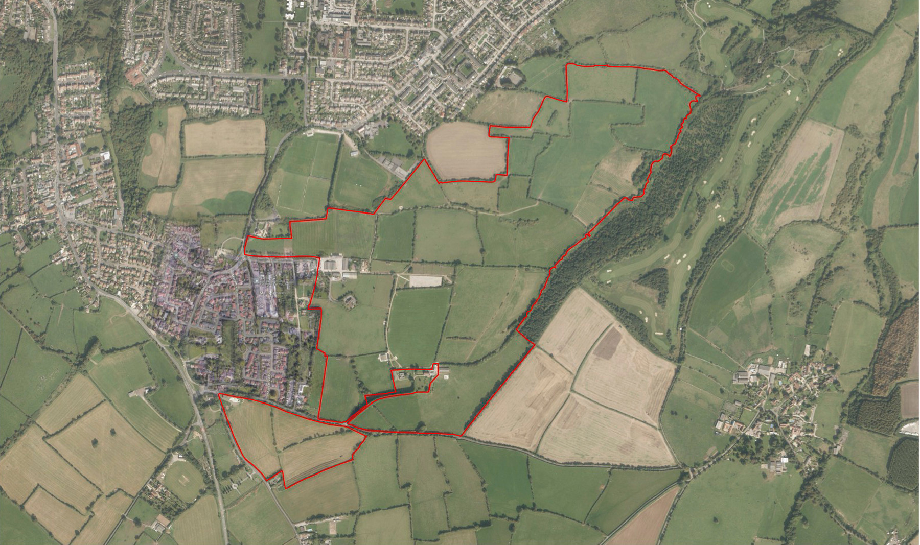
Site location plan
Site Location
The c. 70 hectare site is located on the eastern site of Whitchurch, on land both north and south of Queen Charlton Lane. It is adjacent to the existing residential area of the village, with the eastern edge of the site being defined by the existing a watercourse and dense tree cover, providing a strong physical and visual buffer and edge to the site. The land does not fall within any national or local landscape designations and public access is currently limited to the two public footpaths, including the Priests Path that runs through the site.
Site Connections
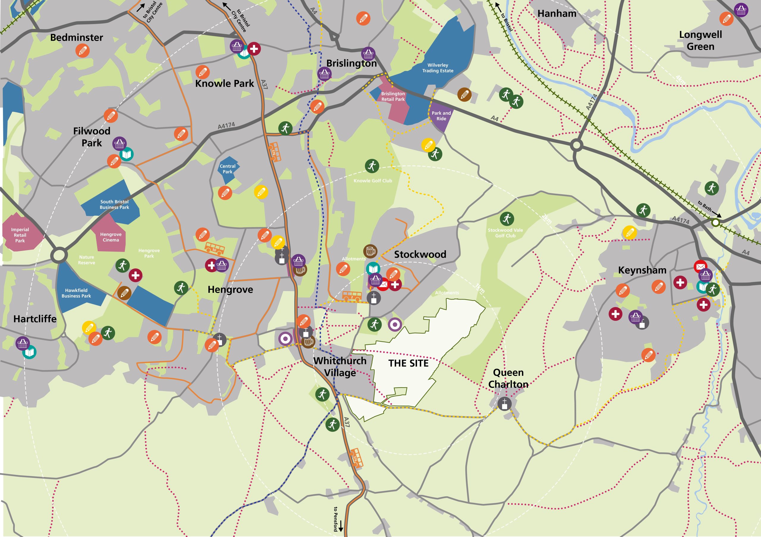
The site is well connected to the centre and a wide range of shops, services and facilities can be easily accessed on foot, by cycle and by public transport. Opportunities have also been identified that we would like to discuss and welcome your feedback on, that will further improve the local walking, cycling and public transport infrastructure to make it easier for the local community to travel within Whitchurch as well as to other places including Keynsham and Bristol.
By car
The main site access points will be:
-
- from the south where the A37 meets Queen Charlton Lane where we are proposing a new signalised junction
-
- from the north via Staunton Lane, with changes to the A37 / Staunton Lane signals to improve traffic flow
These access points will enable a vehicle and public transport loop through the site.
By bus
The site is well connected to the centre and a wide range of shops, services and facilities can be easily accessed on foot, by cycle and by public transport. Opportunities have also been identified that we would like to discuss and welcome your feedback on, that will further improve the local walking, cycling and public transport infrastructure to make it easier for the local community to travel within Whitchurch as well as to other places including Keynsham and Bristol.Local bus routes are currently accessed from Whitchurch village. The scheme is designed to enable new or extended existing bus routes through the site, with an opportunity to enhance the existing bus services and connections between Whitchurch and key destinations beyond including Bristol and Keynsham.
By cycle
Sustrans Route 3 provides a mainly off-road cycle route into Bristol city centre to the north and a long-distance leisure route to the south. We are proposing to invest in further infrastructure – including a new mobility hub and improvements to Sleep Lane and Staunton Lane – to encourage cycling and active travel, including to Keynsham.
By foot
There are opportunities to enhance public footpath connections within the village which are being explored as part of the development. The two Public Rights of Way including the Priest Path, which cross the site, will be retained and carefully integrated into the future development.
By rail
The closest rail station is Keynsham, approximately 5km from the site and accessible by cycle. While there are existing bus services stopping at Temple Meads (from Sleep Lane and Wharnecliffe Gardens), we are also exploring further investment in bus services to better connect to Keynsham and/or Hengrove.
Planning Background
Barwood Land has promoted the land east of Whitchurch
for a number of years. The site was included within a larger ‘Strategic Development Location’ in the draft Joint Spatial Plan
about ten years ago and before that was part of an ‘Area
of Search’ for approximately 6,000 homes in the draft
Regional Spatial Strategy. Part of the site has been identified as an Option for development through the emerging Local Plan.
Bath & North East Somerset Council (B&NES) faces
a substantial housing challenge, and the land East
of Whitchurch is a highly sustainable location to
accommodate a proportion of the housing needs.
B&NES Council is currently preparing its draft local plan.
This plan sets out where development will happen over
the next twenty or so years – and gives the council a lot
more control over planning applications. This draft local
plan will go to the Government’s Planning Inspectorate
for approval.
Our planning application will therefore be considered in
parallel with the Council’s preparation of its local plan.
Currently the site is within the Green Belt. We consider there are a number of factors which combine to justify the release of the land from the Green Belt:
- Given the constrained nature of the Bath and North East Somerset (B&NES) authority area, B&NES accepts Green Belt release will be needed to meet its housing requirement. This pressure has been reinforced by the Government’s changes to the National Planning Policy Framework (NPPF), which has – effectively – doubled the number of new homes B&NES is required to find land for;
- There are only a limited number of sites within the existing urban areas that could contribute towards meeting the market and affordable housing needs;
- We have undertaken extensive studies – including transport, ecology, landscape, drainage and heritage – which show this site is not subject to any overriding technical or environmental constraints which would prevent development;
- The site is well located to support a highly sustainable development.
Flooding & Heritage
The majority of the site is located within Flood Zone 1, with very low probability of flooding. The land does not fall within any national or local landscape designations. It is currently located within the Bristol-Bath Green Belt.
Get in touch
If you have any questions, you can:
- Submit them via the feedback form
- Email: [email protected]
- Call: 0800 193 9403